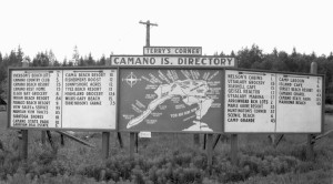
Paul Dorpat, Seattle historical photograph expert shared this photograph with the Stanwood Area Historical Society many years ago. He is a collector of vintage photographs of places in Washington State.
The Camano Island Chamber of Commerce recently updated its Camano Gateway sign at the fork in the road (State Route 532). But this directory shows several now historical places, businesses, resorts, beaches, etc. Note the prominent landmark location referring to Terry’s Corner. This corner used to refer to the intersection of North Camano Drive and Sunrise Blvd which is why there are so many trees in the distance on the hillside behind the sign. There was a stop sign there as there is now. The right turn takes you to Utsalady and the left turn takes you south. This photograph was taken before the fork was put in the State Highway Dept in the 1960s so the photograph would be dated some time in the 1950s or early 60s. It was located at the time at the stop sign intersection beyond the current gateway Camano Island Chamber of Commerce building because S. R. 532 to the south end had not yet bypassed that intersection.
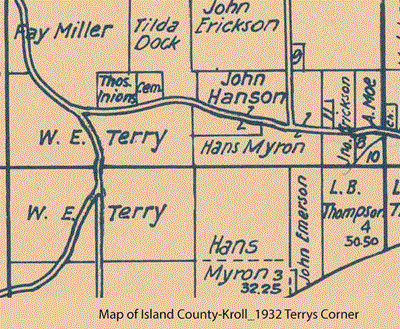
 The name of the photographer has been identified as Charles Terry, the owner of the property at the time. The 1932 Kroll map clipping shows that at the time it belonged to William Terry, Charles father. For more on this history, see the book Camano Island Images of America (Arcadia Publishing, 2006.
If you have information that would further date this photograph, such as the dates that Seashell Café existed, please let us know! Contact us.

